All services are nominal
If you notice a problem, please send us an email via the Contact Us menu of the app.
Average time of model updates on the SailGrib grib server
| Source | Model | Runtime | Available at (TU) |
| NOAA | GFS 025 | 00Z | 5:45 |
| NOAA | GFS 025 | 06Z | 11:45 |
| NOAA | GFS 025 | 12Z | 17:45 |
| NOAA | GFS 025 | 18Z | 23:45 |
| NOAA | GFS 050 | 00Z | 5:30 |
| NOAA | GFS 050 | 06Z | 11:30 |
| NOAA | GFS 050 | 12Z | 17:30 |
| NOAA | GFS 050 | 18Z | 23:30 |
| NOAA | GFS 100 | 00Z | 5:25 |
| NOAA | GFS 100 | 06Z | 11:25 |
| NOAA | GFS 100 | 12Z | 17:25 |
| NOAA | GFS 100 | 18Z | 23:25 |
| NOAA | NAM CONUS | 00Z | 3:30 |
| NOAA | NAM CONUS | 06Z | 9:30 |
| NOAA | NAM CONUS | 12Z | 15:30 |
| NOAA | NAM CONUS | 18Z | 21:30 |
| NOAA | NAM CONUS NEST | 00Z | 3:20 |
| NOAA | NAM CONUS NEST | 06Z | 9:20 |
| NOAA | NAM CONUS NEST | 12Z | 15:20 |
| NOAA | NAM CONUS NEST | 18Z | 21:20 |
| Météo France | Arôme | 00Z | 3:00 |
| Météo France | Arôme | 06Z | 11:30 |
| Météo France | Arôme | 12Z | 16:15 |
| Météo France | Arôme | 18Z | 23:30 |
| Météo France | Arpège Europe | 00Z | 4:00 |
| Météo France | Arpège Europe | 12Z | 15:45 |
| Météo France | Arpège Monde | 00Z | 4:00 |
| Météo France | Arpège Monde | 12Z | 15:45 |
- Press the
 button
 - Press the "GRIB REQUEST" button
- Choose the source of the grib files, usually SailGrib but you can also use Open WRF, SailDocs, Great Circle...
- Choose the weather or current forecast model. The most common is the GFS or :
- in coastal navigation along European coasts, the Arpège 0.1° model of Météo France
- in coastal navigation along the US coasts or on the Great Lakes, the NAM model from the NOAA
- Choose the time step and number of days.
- Select the parameters to be loaded, usually Wind and Pressure or Current
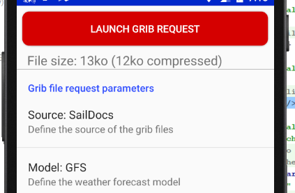
- Press the "REQUEST GRIB" button at the top of the screen
- The file is created on the SailGrib server, sent back to the app and opened in the app.
[youtube id="JZALa7RAqrk" width="600" height="350" autoplay="no" api_params="" class=""]
Iridium has been selling the Iridium Go since Q3 2014. The unit connects quickly and automatically to Iridium satellites and creates a Wi-Fi hotspot i your boat. You can use the Go with your smartphone (iPod or Android), tablets and computers.
Some suppliers offer prepaid plans with unlimited data for the Go at around 140€/month. It is an excellent choice for an Atlantic crossing.
To start using your Iridium Go, install on your Android device:
- Install the Iridium Go app on your android device:
https://play.google.com/store/apps/details?id=com.iridiumgo - Install the Mail and Web app on your android device:
https://play.google.com/store/apps/details?id=com.iridium.mailandweb
- Register with Iridium to get a specific "Iridium" email address ending with @myiridium.net :
https://www.iridium.com/mailandweb/
If your provider is GMN-XGate, install the XGate Satellite Email & Web app instead of Iridium Mail & Web and there is no need to create an @myiridium.net email address, XGate will give you an @gmn-usa.com address.
Once installed, enter in SailGrib at the bottom of the Grib Request page the email address registered with your provider, usually Iridium or XGate.

In SailGrib, you will get the grib files by an exchange of emails.
You must use SailDocs, or possibly GMN and Great Circle, as the Source of your grib files.
The Source is defined in the Request Grib screen.

You will get a grib file with an email exchange:
- press the
 button
 - press the REQUEST GRIB button
- select a source: SailDocs or SailGrib
- select a model, usually the GFS
- if you picked SailGrib as a source, set the request mode to Email
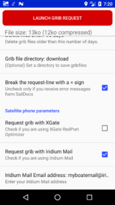
- at the bottom of the screen, check the box "Make the grib request with Iridium Mail" and enter your iridium email address
- press the LAUNCH GRIB REQUEST button. An e-mail is prepared and sent to the "Iridium Mail & Web" app
In the Iridium Mail & Web app:
- send the email with the iridium network
- wait for 5 minutes
- press the send/receive button again. You should have received an email from SailDocs or SailGrib with a grib file attached
- save the grib file
In SailGrib:
- press the
 button
 - press the OPEN GRIB button
- choose the grib in the list, the last one saved is at the top of the list
The maximum reasonable maximum size of an grib received by iridium is about 70 kb, adjust your settings accordingly. For example, to get the whole Atlantic, set the grid resolution to 2.5°.
But most of all, practice on the ground before you set sails. First in 3G or WiFi to make sure you set the settings correctly to get a grib file size of 70kb or less. Then, with the iridium Go to get a file in near-real conditions. It is preferable to use an external antenna with the iridium Go. If you haven't put the Go outside, it will work better.
One of SailGrib's special features is the ability to load grib files from multiple providers called Sources in the app. Each of the Sources gives access to different Models.
Below you will find a list of the different models supplied, sorted by supplier:
The grib server we created should be your default source when you are connected to the Internet. It provides grib files of weather forecasts (wind, pressure, cloud, rain), waves, ocean currents and tidal currents. We access 4 suppliers: NOAA the US National Oceanic and Atmospheric Administration , Météo France, the German Weather Service DWD and Copernicus, the Europe's eyes on Earth.
Wind, Pressure: GFS, Arpège Monde, Arpège Europe, Arôme, ICON EU, NAM, NAM Nest
Waves: WW3
Ocean currents: Global, global Met
Tidal currents: IBI, ENWS, Baltic, Med
1 - NOAA Models
- GFS: This is a global model that covers the entire globe. The data are available on a grid of 0.25° (27km) every 3 hours, from 0 to 192 hours and then on a grid of 2.5° beyond, up to 384 hours (16 days). Data are calculated for 00:00,06:00,12:00 and 18:00 GMT. They are available in HH +05h. Available data are: wind and pressure, clouds and rain. It is used offshore by all sailors, whether cruising or racing.
- NAM and NAM nest: The NAM model covers the United States. Data are available on a 12km (0.12°) grid every hour up to 84 hours. The NAM model is available with a grid of 3km (0.03°) every hour up to 60 hours. Data are calculated for 00:00,06:00,12:00 and 18:00 GMT. They are available in HH +03h30. Available data are: wind and pressure.
- WW3: This is NOAA's WaveWatch III wave model. The model is global but covers only open seas. The data are available on a grid of 0.5° (52km), every 3 hours, from 0 to 180 hours. The data are calculated for 00:00,06:00,12:00,18:00 GMT and are available in HH +06:00. The available parameters are wind, significant wave height, mean direction and mean wave period.
2 - Méteo France models
- Arpège Monde: the Arpège Monde model covers the whole world on a grid of 0.5° (55km). It provides 3 or 4-day forecasts depending on the calculation cycle. The data are calculated at 00:00, 06:00, 12:00, 18:00 GMT and are available approximately in HH +05h.
- Arpège Europe: the Arpège Europe model covers Europe on a grid of 0.1° (12km). It provides 3 or 4-day forecasts depending on the calculation cycle. The data are calculated at 00:00, 06:00, 12:00, 18:00 GMT and are available approximately in HH +05h. The Arpège Europe model is excellent for any offshore navigation in European waters.
- Arôme The Arôme model covers France at a very high resolution of 0.025° (2.5km) over 2 days. The data are calculated at 00:00, 06:00, 12:00, 18:00 GMT and are available approximately in HH +05h. It is a model perfectly adapted for coastal routing in France.
3 - German Weather Service DWD Models - ICON GLOABAL and ICON EU
- The DWD ICON-GLOBAL model, available in SailGrib since June 27, 2021, covers the entire world with a 0.125° (~ 13 km) grid. It provides forecasts for 180 hours (7.5 days). Data are computed at 00:00 and 12:00 GMT and are available about 4 hours later (HH +04:00). The time step for the forecast period up to +78 hours is one hour, the forecast periods between +81 and +120 hours are covered with a 3 hour interval. The ICON-GLOBAL model is the only high resolution model covering the whole world. It is excellent for any navigation and is especially recommended in all areas not covered by other fine mesh models.
- The DWD's regional ICON-EU model came into operation on 21.07.2015. The grid spacing is 0.0625 °(~ 7 km). The ICON-EU forecasts are available up to 5 days. The data are calculated at 00:00, 06:00, 12:00, 18:00 GMT and are available approximately in HH +04h . The time step for the forecast period up to +78 hours is one hour, the forecast periods between +81 and +120 hours are covered by a 3-hourly time step. As the letters 'EU' suggest, the ICON-EU model covers the whole of Europe. In the west and east, however, the model's coverage extends far beyond the European territory, covering the area bounded by the coordinates 23.5°W–62.5°E, 29.5°N–70.5°N. The ICON EU model is excellent for any navigation in European waters.
4 - Copernicus Models - Mercator Ocean
Copernicus is a European ocean observation and prediction project.
- tidal current model (Copernicus IBI): The IBI model (Iberian Biscay Irish) provides a 5-day hydrodynamic forecast that includes tidal current forecasts, those resulting from weather forecasts, river flows, etc. Its resolution is 0.03° (3km) and its time step of 1 hour. As its name indicates, it covers the European Atlantic coasts and the English Channel (26n, 56n, 19w, 5e). It is ideal for routing along these coasts. It covers the Strait of Gibraltar.
- ocean current model (Copernicus Global). The Copernicus Global model provides a 7-day hydrodynamic forecast. Its resolution is 0.08° (9km) and its time step of 24 hours. As its name suggests, it covers all the seas of the Globe. It is ideal for routing in the presence of ocean currents such as the Gulf Stream.
- Ocean Current Model (Copernicus Met Global): The Met Global model provides a 7-day hydrodynamic forecast. Its resolution is 0.25° (27km) and its time step of 24 hours. As its name suggests, it covers all the seas of the Globe. It is ideal for routing in the presence of ocean currents such as the Gulf Stream.
- Baltic Sea tidal current model (Copernicus Baltic): The Baltic model provides a 2-day hydrodynamic forecast. Its resolution is 0.2° (2km) and its time step of 1 hour. As its name implies, it covers the Baltic Sea[Lat: 53N/66N Lon: 9E/30E]".
- Mediterranean Sea Current Model (Copernicus Med): The Med model provides a 9-day hydrodynamic forecast. Its resolution is 0.06° (7km) and its time step of 1 hour. As its name implies, it covers the Mediterranean Sea.
- Northern European Current Model (Copernicus ENWS): The ENWS model provides a 5-day hydrodynamic forecast. Its resolution is 0.06° (7km) and its time step of 1 hour. It covers the European coasts from Portugal. [Lat: 65N/40N Lon: 20W/13E]
SailDocs is a free service that provides grib files through an email exchange: the user sends a request generated by SailGrib via email. It will usually receive an email with a grib file attached within 5 minutes. This service is mainly used offshore with a very low bandwidth Iridium connection like an Iridium Go.
- GFS: most often used. Produced by NOAA. It is a global model that covers the entire globe. Data are available on a grid of 0.25° (27km) every 3 hours, from 0 to 192 hours, then on a grid of 2.5° (277km) beyond 384 hours (16 days). Data are calculated for 00:00,06:00,12:00 and 18:00 GMT. They are available in HH +05h00. The available data are: wind, pressure, precipitation, cloud cover, air temperature, significant wave height, and CAPE.
- WW3: This is the NOAA WaveWatch III wave model. The model is global. The data are available on a grid of 1 ° (111 km), every 3 hours, from 0 to 180 hours. The data are calculated for 00:00, 06:00, 12:00, 18:00 GMT and are available in HH +06h. The available parameters are wind, significant wave height, mean direction and mean wave period.
- COAMPS: This is a regional model calculated by the US Navy. Data are available for only four regions: Europe and the Mediterranean Sea, the Eastern Pacific, the Western Atlantic, and the Caribbean Sea and Central America. The data are available on a grid of 0.2 ° (22km) in 6-hour intervals, from 0 to 72 hours for Europe and the Mediterranean Sea as well as the Western Atlantic and 48 hours for the other 2 regions. The available parameters are wind and pressure. The following regions are available:
- Europe and the Mediterranean Sea: 29N, 66N, 15W, 45E
- Pacific-East: 29N, 60N, 160W, 114W
- Western Atlantic: 20N, 55N, 093W, 055W
- Caribbean Sea and Central America: 00N, 32n, 120W, 060W
Great Circle is a provider of grib files mainly used by offshore racers through its Squid software. Any user registered on their site can upload grib files with a free subscription. Great circle sells other subscriptions that I invite you to discover on their website. SailGrib gives you access to all the models included in your subscription; simply enter the email address used to register your account as well as your password.
With a free subscription, you will have access to the GFS and GEM models.
- GFS: Produced by NOAA. It is a global model that covers the entire globe. The data are available on a 0.5 °(27km) grid every 3 hours, from 0 to 192 hours, then on a grid of 2.5° beyond 384 hours (16 days). Data are calculated for 00:00, 06:00, 12:00 and 18:00 GMT. They are available in HH +05h.
- GEM: This is a global model produced by the Canadian Meteorological Centre (CMC) that covers the entire globe. Data are available on 0.6° (66km) grid every 3 hours, from 0 to 192 hours. Data are calculated for 00:00, 06:00, 12:00 and 18:00 GMT. They are available in HH +05h.
Open WRF files are produced using the WRF model. The grib files are offered in two resolutions of 0.11° (12 km) with a 5-day forecast and 0.4° (4 km) with 2-day forecast.
In addition to the classic data, gribs include: gusts, a storm indicator, WAM waves, Copernicus marine currents. We recommend that you use these grib files in the Mediterranean.
In addition to its satellite telephony provider activities, GMN (Global Marine Networks) provides free grib files.
The GMN grib server can be accessed by email or download.
This server has 2 unique features:
- if you specify a size limit for the grib file, the server will interpolate the template data to get as close as possible to your limit. This is ideal for Iridium email requests.
- GMN has 2 models in exclusivity:
- Hycom: a model of global ocean currents with high resolution 0.08° (8km). This model is often considered to be the best and especially for the Gulf Stream.
- FNMOC: the Navy's wave model. It covers all the seas of the Globe, including the Mediterranean.
You will also find the models GFSat 1° (111km) and ww3 at 1° (111km).
You have several options to scroll through time
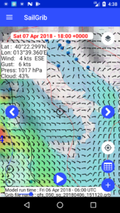
- Press the date at the top of the screen and select a date and time from the drop-down list
- Press the
 or the
 button to move from one time step to the next or previous one
 - Press the
 button at the bottom of the screen to scroll through time automatically
 - Drag the slider at the bottom of the screen to select any time
- Press the
 button to center the map on your position and view the forecasts for now
- Open the menu by pressing the menu top left button
 or dragging the drawer to the right
 - Tap the Display menu
- Set the various options including:
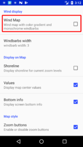
- Wind Map: will display a map with black wind barbs and a gradient of colors according to wind speed. This display consumes a lot of resources
- Windbarb width: increase it if you have a very high definition screen
- Shoreline: allows you to view the world shorelines. Convenient when at sea if you have not downloaded the maps for your navigation area in the app cache
- Units: choose wind speed, wind direction and temperature units
FAQs
One type of display requires a lot of CPU and that might cause lagging.
If your display looks like this, you have checked the wind map option in the Display menu.

Please uncheck it and it should be Ok.

The FREE version is limited to 2 days of forecast with the GFS 0.50° model and the visualization of the tide of the day.
The Premium option includes the same features as the paid version of the application:
- up to 16 days of forecasting with the GFS model
- high-resolution models: Arpège in Europe, Aroma in France, NAM in the United States
- ocean current models for all the world's seas
- tidal current models for European waters
- the calculation and visualization of tides in the world's major ports at any given date
You have the choice between subscribing for 3 months or 1 year or buying the Premium option for life. Note that the renewal of subscriptions is automatic unless the subscription is cancelled.
To purchase the Premium option:
- Open SailGrib Free
- Go to the menu
- Press the PURCHASE button
- Choose your type of subscription or purchase for life
- Press the SUBSCRIBE or BUY button
To cancel a subscription:
- Open the Google Play Store
.
- Tap Menu
Account
Subscriptions.
- Find the subscription you want to cancel.
- Tap Cancel.
- Be sure to register your new Android phone with Google using the same Gmail address.
- Open the Play Store application
- Search for SailGrib
- Install the application
Yes, you can install the app on as many devices as you want as long as they are registered with Google using the same Gmail address.
No. Today, SailGrib only runs on Android:
- phones and tablets (Samsung, Sony, Motorola, Huwei, LG,...)
- Chromebooks supporting the Play Store. You will find the list by following this link
No. Today, SailGrib only runs on Android:
- phones and tablets (Samsung, Sony, Motorola, Huwei, LG,...)
- Chromebooks supporting the Play Store. You will find the list by following this link
On a PC, you can install an Android emulator that will allow you to install SailGrib but you will have a degraded experience of the app. You will find a list of Android emulators by following this link.
It depends if you have a recent Chromebook or not. You can install SailGrib on Chromebooks that support the Play Store. You will find the list by following this link.
Yes! We publish 3 other app for boaters and racers:
- SailGrib WR, our flagship app, includes all the features you'll need to sail: weather, tides, currents, easy to use but very powerful routing, a NMEA link, AIS with alarms, integrated purchasing or downloading of marine charts.
- With SailGrib AA, our anchor alarm app, the position of your boat will be constantly monitored. In the event of a confirmed alarm, an alarm will sound and you will receive an SMS. Leave a phone plugged into your boat and you have an anti-theft alarm!
- With SailGrib RS, our racing start app with a simplistic design, you'll know in real time where you are positioned in relation to the line and whether you're early or late for the start of the regatta.
Visit our Google Play Store page to install them!
If the Play Store asks you to buy the application when you have already done so in the past with the same Gmail address, it's probably because the data in the Play Store app is corrupted. To repair that:
- Open your device's Settings app
.
- Tap Apps & notifications
See all apps.
- Scroll down and tap Google Play Store
.
- Tap Storage
Clear Cache.
- Next, tap Clear data.
- Re-open the Play Store & try your download again.
If this doesn't solve the problem, try following Google's advice by clicking on this link.
Bought subscriptions are automatically renewed.
To cancel a subscription:
- Open the Google Play Store
.
- Tap Menu
Account
Subscriptions.
- Find the subscription you want to cancel.
- Tap Cancel.
Before contacting us, please read the help and FAQs carefully. Most of the time, you will find the answer to your questions.
If you have not found the answer, send us an email using the Contact Us menu of the application.
We usually answer questions very quickly. If not, we're probably at sea testing the latest developments!
Thank you for your patience.
Additionally, there are times where you are required buy term paper to prepare essays for urgent however, in addition, there are times when you are totally free to choose which kind of essays you need to compose for the day.

