If your marine instruments provide wind data, SailGrib calculates the up and downwind laylines.
If your marine instruments calculate the true wind, it will be used, otherwise the app will use a simplified calculation of true wind.
Laylines include the effect of the current. You can choose different calculation modes:
- Ignore current
- Currents calculated based on the difference between SOG/COG and STW/CTW. This is the default mode. The calculation will take into account not only current but also the drift. You must have perfectly calibrated navigation instruments to get a correct result.
- Currents calculated from the atlases of current. This is the best choice if the instruments are not perfectly calibrated.
- Currents calculated from a grib of current. The reference is the latest grib used for routing.
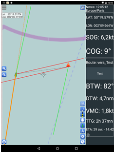
If you have not activated a waypoint in the navigation panel, laylines will be drawn from the boat. The length of the layline matches the length of the COG predictor arrow in the AIS parameters.
If a waypoint is activated in the navigation panel and if a tack or a jibe is required to reach the waypoint, the tacking or gybing point is calculated. Laylines are drawn and truncated at the optimum tack point. The distance to the layline and the time to reach the layline can be displayed in the NMEA panel.
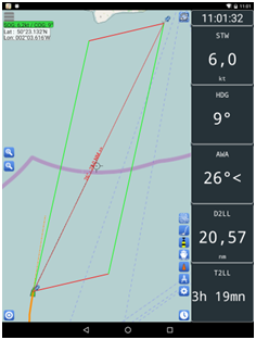
We see in the below example that:
- The boat is sailing upwind at a slightly angle higher than the optimum one,
- The distance to the layline is 20.57 NM
- The sailing time to reach the layline is 3 hours 19 minutes
If the boat is over the layline, laylines are drawn from the boat and from the waypoint.